A new integrated search interface will become available in the next phase of marineinfo.org.
For the time being, please use IMIS to search available data
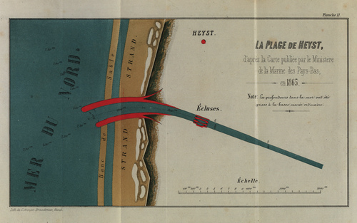
De Maere-Limnander (1866, pl. 2) Description Het strand van Heist, naar de kaart die werd uitgegeven door “Le Ministère de la Marine des Pays-Bas” in 1865. Op de kaart is een ontwerp voor de latere haven van Zeebrugge te zien.Schaal: 1/10000JPG file - 3.26 MB - 3 571 x 2 239 pixels Extra information added on 2008-06-191 476 viewsFrom reference De Maere-Limnander, A. (1866). Des communications directe...FileName: 15949.jpg FileDateTime: 1213878779 FileSize: 3255133 FileType: 2 MimeType: image/jpeg SectionsFound: ANY_TAG, IFD0, THUMBNAIL, EXIF COMPUTED.html: width="3571" height="2239" COMPUTED.Height: 2239 COMPUTED.Width: 3571 COMPUTED.IsColor: 1 COMPUTED.ByteOrderMotorola: 1 COMPUTED.Thumbnail.FileType: 2 COMPUTED.Thumbnail.MimeType: image/jpeg Orientation: 1 XResolution: 300/1 YResolution: 300/1 ResolutionUnit: 2 Software: Adobe Photoshop Elements 3.0 Windows DateTime: 2008:06:18 10:46:10 Exif_IFD_Pointer: 172 ColorSpace: 1 ExifImageWidth: 3571 ExifImageLength: 2239 Click here to return to the thumbnails overview |
