A new integrated search interface will become available in the next phase of marineinfo.org.
For the time being, please use IMIS to search available data
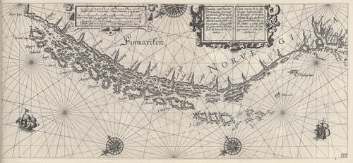
Blaeu (1612, kaart 35) Description Pascaarte vant Noordersche deel van Noorwege van Dronten aff tot om de Noortcaap toen met alle de eylanden aende selfde custen geleghen, alles gestelt op zyne rechte streckinghen en behoorlycke distantien = Carte marine de la partie plus Septentrionale de Norwege, de Dronten jusques au dela du Nortcap avecq toutes les isles situeez a icelle coste, le tout mis selon ses vraijes routes et exactes distancesDatum: 1612Plaats: Noord-Noorwegen en FinmarkenJPG file - 3.60 MB - 6 621 x 3 071 pixelsadded on 2011-08-121 101 viewsFrom reference Skelton, R.A.; Blaeu, W.J. (1964). The Light of Navigatio... (page [303])Click here to return to the thumbnails overview |

