A new integrated search interface will become available in the next phase of marineinfo.org.
For the time being, please use IMIS to search available data
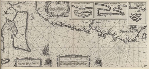
Blaeu (1612, kaart 36) Description Pascaarte van een deel van Noorweghen ende van laplandt, vertoonende eijghentlijck de gheleghentheijt der Zeecusten die tusschen de Noortcaap en de mondt vande witte zee zijn gheleghen = Carte marine d'une partie de Norvegue et de Laplande, monstrant la vraije situation des costes marines, entre le Cap de Nord et l'embouchure de la Mer blancheDatum: 1612Plaats: Noord-Europees RuslandJPG file - 3.88 MB - 6 630 x 3 059 pixelsadded on 2011-08-121 288 viewsFrom reference Skelton, R.A.; Blaeu, W.J. (1964). The Light of Navigatio... (page [310])Click here to return to the thumbnails overview |

