A new integrated search interface will become available in the next phase of marineinfo.org.
For the time being, please use IMIS to search available data
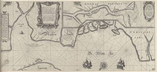
Blaeu (1612, kaart 38) Description Pascaarte vande witte zee, vertoonende de rechte ghelegentheijt vande zeecusten, mitsgaders aller Havenen, Inwijcken, Eijlanden, ende Riviere aldaer gheleghen alles op rechte streckinge en wijdde van mijle gestelt = Carte marine de la Mer blanche, monstrant la situation des costes, ensemble touts Goulfes, Isles et Rivieres d'icelles, le tout dressé selo ses vraijes routes et distaces + Afbeeldinghe vande Riviere va Archangel vande mont af totte Stadt Archegel ofte S. Michiel toe = Poutraict au vif de la Riviere d'Archangel, de l'embouchure dicelle iusques a la ville de S. MichaelDatum: 1612Plaats: Witte ZeeJPG file - 4.08 MB - 6 592 x 3 036 pixelsadded on 2011-08-121 223 viewsFrom reference Skelton, R.A.; Blaeu, W.J. (1964). The Light of Navigatio... (page [316])Click here to return to the thumbnails overview |

