A new integrated search interface will become available in the next phase of marineinfo.org.
For the time being, please use IMIS to search available data
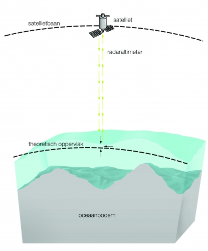
Satellietmeting van het zeeniveau en onderwaterreliëf Description De zeespiegel reageert op de zwaartekracht. Deze weerspiegelt de massaverdeling over aarde. De onregelmatige vorm die hiervan het gevolg is, noemen we de geoïde. Dankzij satellietmeting hoeven we niet over elke meter oceaanbodem te varen om deze met sonar in kaart te brengen. Dit zou 200 scheepsjaren en miljarden euro’s kosten.JPG file - 1.85 MB - 2 480 x 2 994 pixels Extra information added on 2013-12-16592 viewsFrom reference Copejans, E.; Smits, M. (2011). De wetenschap van de zee:...FileName: 81003.jpg FileDateTime: 1387192011 FileSize: 1851904 FileType: 2 MimeType: image/jpeg SectionsFound: ANY_TAG, IFD0, THUMBNAIL, EXIF COMPUTED.html: width="2480" height="2994" COMPUTED.Height: 2994 COMPUTED.Width: 2480 COMPUTED.IsColor: 0 COMPUTED.ByteOrderMotorola: 1 COMPUTED.Thumbnail.FileType: 2 COMPUTED.Thumbnail.MimeType: image/jpeg Orientation: 1 XResolution: 3000000/10000 YResolution: 3000000/10000 ResolutionUnit: 2 Software: Adobe Photoshop CS4 Windows DateTime: 2011:10:15 08:46:49 Exif_IFD_Pointer: 164 ColorSpace: 65535 ExifImageWidth: 2480 ExifImageLength: 2994 Click here to return to the thumbnails overview |
